
Settlement begins
Local railroad-history research identifies Samuel Holliday's first settlement efforts in the area in 1755.
Historic McVeytown · Archive
McVeytown grew from an eighteenth-century river settlement into a canal town, railroad stop and compact borough. This page gathers the early story, surviving landmarks and links to photographs, maps and records held by historical archives.
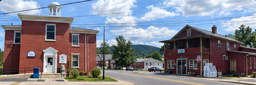
The Juniata corridor shaped McVeytown from the beginning: first as a route through the valley, then through turnpike, canal and railroad eras.
Local railroad-history research identifies Samuel Holliday's first settlement efforts in the area in 1755.
Holliday is recorded as settling permanently in the McVeytown area.
County history records John McVey settling here in a log house; the borough would later carry his name.
The town was formally laid out as Waynesburg on land associated with John McVey.
The Pennsylvania Canal reached Mifflin County, accelerating growth in river communities including McVeytown.
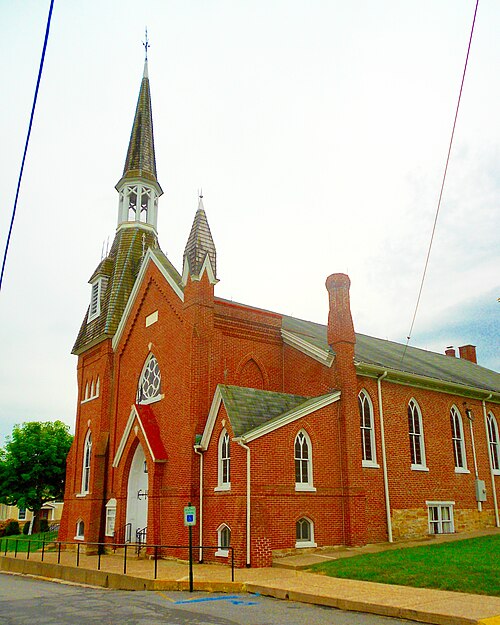
McVeytown was incorporated April 9; the Presbyterian congregation also replaced its earlier stone church with the brick building that survives today.
The Pennsylvania Railroad reached the McVeytown area; public passenger service began December 24, 1849.
The 1900 census counted 520 residents — substantially more than the borough's population today.
That was how Sherman Day described McVeytown — still noted as formerly Waynesburg — in his 1843 account of Pennsylvania. He recorded new brick and frame houses, Methodist and Presbyterian churches, and nearby furnace, foundry and forge activity. The 1840 population was listed as 348.
The canal did more than move goods. It tied the borough to a wider transportation network along the Juniata, helping turn what had been a small settlement into a place with manufacturing, trade and regular connections to Lewistown and points west.
“Quite a flourishing village on the canal.”
Sherman Day, 1843 · historical description of McVeytown
Born in McVeytown on April 9, 1839, Rothrock became a physician, botanist and foundational figure in Pennsylvania forestry. His work helped shape the Commonwealth's early forest-conservation program.
The local Presbyterian congregation dates its formal beginning to 1783. A small stone church preceded the brick sanctuary built in 1833; the Gothic-front changes are associated with the 1870s.
The McVeytown Journal began in 1873. A 1903 newspaper directory described it as a Thursday independent paper with a reported circulation of 700.
Browse historic postcards, maps, census records, railroad material and newspaper references connected to McVeytown and the Juniata River Valley.
Wikimedia Commons identifies a pre-1923 postcard showing the same church building that stands on North Queen Street today.
View historic postcard ↗Wikimedia Commons preserves several historical portraits of McVeytown-born Joseph Trimble Rothrock, including period magazine and Library of Congress images.
Open Rothrock image archive ↗The Atlas of Perry, Juniata & Mifflin Counties includes an Oliver Township / McVeytown town map — useful for tracing streets, lots and property owners.
Browse 1877 atlas index ↗National Archives enumeration-district material identifies McVeytown Borough as ED 44-30, with Oliver Township outside the borough listed separately.
View NARA scan ↗The U.S. Geological Survey maintains a historical 1:24,000 McVeytown quadrangle showing the borough and surrounding ridges, river and transportation corridors.
Open USGS historical map ↗The 1903 directory records a population of 520, the Pennsylvania Railroad and canal, local industries, and the weekly McVeytown Journal.
Open 1903 volume ↗The Historic American Engineering Record documents the Juniata Division and cites the 1976 McVeytown-area bicentennial history among its sources.
Read canal history ↗Railroad-history material documents the line reaching McVeytown in 1849, the station across the river near Manayunk, and later valuation maps.
Explore railroad archive ↗Mifflin County's historical bibliography records the Journal beginning in 1873 and notes surviving filmed issues held with Pennsylvania newspaper collections.
See newspaper holdings ↗A published family photograph identifies an early service station on old Route 522 in McVeytown; the station was later moved in 1933.
View the family photograph ↗Historical sources consistently identify the laid-out settlement as Waynesburg before the McVeytown name became established. The name honored John McVey, whose association with the site preceded the 1795 town plan.
Railroad history notes that the Pennsylvania Railroad's McVeytown stop was technically on the opposite side of the Juniata, in the village known as Manayunk.
The Presbyterian congregation was organized while the community was still called Waynesburg. Its brick church went up in 1833, the same year as the borough's incorporation act.
The 1900 census counted 520 people in McVeytown. A 1903 directory also listed flour milling, foundry work, iron mining and mineral-grinding activity around the town.
These are the strongest public sources used to build this page and are good starting points for family or property research.